

Iceland’s geological wonders make reality look like science fiction during grand tour of island
(Second of a three-part series)
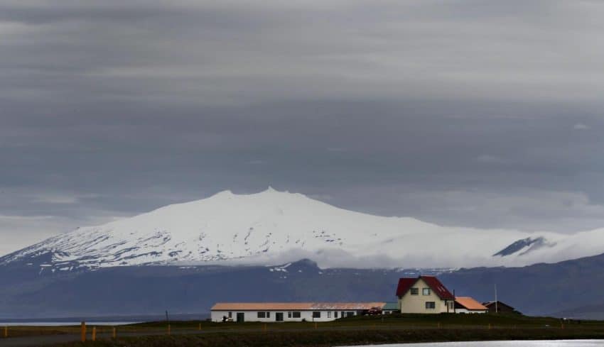
SNAEFELLSJOKULL NATIONAL PARK, Iceland — It sits along the side of the road like a spaceship from another planet, one that’s the size of a small town hovering menacingly over a major American city. Snaefellsjokull is not only hard to pronounce (it’s snay-FELL-syo-koot), it’s hard to comprehend. The mountain is only 4,744 feet high. In the Rocky Mountains near where I lived for 23 years, that’s a pitcher’s mound. But it’s the shape. It is massive. It starts out in foothills and ascends forever until it tops out with a giant snow-capped crater.
Parked in my rented Chevy Spark at the side of the Ring Road (Rte. 1) in West Iceland, I thought how Jules Verne may have stood in this very spot in the 1860s. Hmm, he thought. This looks like the perfect venue for a science fiction book about a terrifying voyage to a steaming, desolate place no one would ever consider visiting. No, not Nebraska. He went on to pen “Journey to the Center of the Earth” using Snaefellsjokull as the journey’s entry point. The book helped Verne become “the father of science fiction” and make him the second most translated author since 1979, right behind William Shakespeare.
More than 150 years later, Snaefellsjokull still inspires the 2 million visitors who come to Iceland every year. It inspires people to hike, to paint, to dream. It also inspires people like me to write. After spending 12 days in Iceland, the most inspiring thing I can write about Snaefellsjokull is this.
Among all the geographic wonders Iceland offers, Snaefellsjokull barely stands out other than its size.
True. Iceland’s nature is a geological kaleidoscope filled with images that leave you open mouthed as you nearly drive off the Ring Road. Snow-capped volcanoes. Turquoise-tinted icebergs. Glistening glaciers. Lava fields. Molten magma. Puffin-covered cliffs. Half-destroyed islands. In a country the size of Colorado are enough geographic wonders to fill a volume of National Geographics. Iceland often only gets in the news when one of its 30 active volcanoes erupts and sends broadcasters scurrying to learn how to pronounce the damn things. But Iceland is more than Mother Nature blowing her fuse. You can’t compare it to one woman. Iceland is a beauty pageant, with spectacular sights at every turn.
I saw most of them. Here are just the highlights, broken down by region as I covered 2,101 kilometers. It was my journey to the center of Earth’s most remarkable geological nation.
SOUTH ICELAND
At 1:45 a.m. on Jan. 23, 1973, the little island of Heimaey (HAY-my) knocked the Vietnam War off front pages around the world. Only 5.2 square miles, it became a smoke-filled cauldron of molten lava. The island’s volcano erupted, sending fire 150 meters into the air. The earth on the island just 4 1/2 miles from the mainland split open. Island officials ordered an evacuation. By incredible luck, bad weather the day before kept every boat in the harbor, allowing all but 200-300 of the 5,273 people to get off the island. Only one person died. A man with drug problems used the panic to break into a pharmacy where he was overcome by toxic gases.
More than 1,400 homes were destroyed under 50 meters of lava. The volcano emitted smoke all the way until spring. About 1,200 islanders returned. About a third never returned to the island forever called the “Pompeii of the North.”
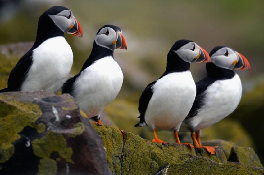
From the port town of Landeyjahofn, I took the 30-minute ferry ride to Heimaey where puffins, those cute, red-beaked birds who made careers out of crash landing on nature videos, stared at us from nearby cliffs. The town still has charm. On one of only three sunny days out of my 12, the little harbor and brightly painted boats looked peaceful in their protective cove.
But when I hiked up through the remnants of that 1973 explosion, I saw the dangers of living on a volcanic island. The lava field stopped just about 50 meters from backyards of dozens of houses. In the Eldheimar volcano museum is a preserved house buried by the lava. The family of four escaped but never returned. Scattered around the house were silverware, shelves and coffee cups. A toilet remained riveted in place.
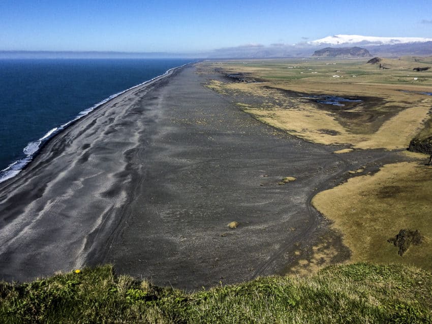
On my first night on the road, I stayed in a charming AirBnB on a farm near the town of Vik. A long gravel road led me to a lighthouse with a breathtaking panorama view of the South Iceland coast. Way below me was a black sand beach that stretched all the way to a snow-capped mountain range. To my left was a perfect arch, carved by the sea, sticking out of the water like a giant wedding ring.
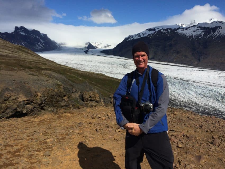
Further east lies Vatnajokull National Park, also known as Skaftafell after the nearby town. Vatnajokull is why they call it “Iceland.” It’s the biggest icecap outside the poles, covering 3,100 square miles, a little smaller and a lot colder than Puerto Rico, at an average of 1,300 feet thick. It covers 8 percent of Iceland. On a map it looks like someone took a knife and carved out most of Southeast Iceland, leaving nothing but a giant white hole.
In the summer, Skaftafell is Iceland’s Yellowstone. About 300,000 people a year come to walk the glaciers, hike the trails and camp in the wilderness. However, in May I practically had to myself the 2 ½-mile hiking trail to Skaftafellsjokull glacier. Of course, it probably helped that I chose a day in the mid-40s with a vicious headwind that made the relatively easy incline seem like the last stage of K2. About halfway up, I asked a descending couple about the glacier and the man started laughing. The woman said, “Windy. Much windier than here.”
When I reached the glacier, it looked a giant, icy river descending from a mountaintop before petering out just before the North Atlantic. As I leaned into the wind trying to keep my balance, another hiker took four shots of me before he finally took one without his hands shaking.
The day got colder. I drove farther east where just off the Ring Road is the Jokulsarlon lagoon with the most remarkable sights I’ve ever seen. Floating all through the lagoon are icebergs. They are icebergs of every size from large buildings to chairs, all floating peacefully in water that feels colder than the dark side of Mars. From the ridge above it, the icebergs had an odd turquoise tint as if they were backlit. They had fallen off Breidamerkurjokull, a section of Vatnajokull, and take their sweet time on their way to the North Atlantic. The journey sometimes takes about five years.

I scurried down the embankment to the black sand beach. Huddled in my hooded windbreaker that flapped in the vicious, icy wind, I dipped my hand into the water. My fingers throbbed for five minutes. Your body wouldn’t last that long if you fell in. And this is late May.
EAST ICELAND
If you read Part I of my Iceland blog, you’ll know that Iceland is the fourth most expensive country in the world and has exorbitant taxes that would shock pre-revolutionary France. I pondered this as I carefully maneuvered my car up steep mountain roads strewn with gravel and dirt. “Hey, it’s great they get paid maternity leave,” I muttered under my breath as I negotiated a hairpin turn with no guardrail. “But how ‘bout paving a road or two?”
Once in East Iceland, I got off the Ring Road. Suddenly the road looked like something out of the nether regions of Nepal. Ruts. Dirt. Rocks. I zigzagged up hills, passing cars too afraid to slip backward over a ravine. I wrote a government contact in Reykjavik asking, not in these words, “Why am I paying $13 for a beer because 75 percent goes to taxes yet I’m driving on roads that would piss off Julius Caesar?” She wrote that with only 330,000 people, Iceland has only 130,000-160,000 taxpayers, and “priority is vital. Having paved roads for very few people (was) not seen as being important.” But she added, “with growing tourism it is of course no longer the case.”
While the tourism department tries convincing the government to do something, bad roads are nearly impossible to avoid in East Iceland, mainly because it’s so worth seeing. Look at a map and the east coast looks like dozens of little fingers sticking into the sea. Those are all fjords. The Ring Road goes up, down and around the peninsulas like ribbons around Christmas packages. Everywhere I drove I had fantastic views of the frigid North Atlantic, lapping up against rocky shores, nary a village insight.
But once veering inland to follow a shortcut, I ran into problems. The Ring Road was built in 1973. Locals tell me before that, most of the country’s road looked like the one that made me more nervous than descending the French Alps during the Tour de France. Then it began to rain. I saw cars spinning their wheels trying to negotiate hills.
My trusty Spark made it but then came another shortcoming of the Icelandic road system. I couldn’t find a gas station since leaving that morning. My gas meter flashed red, torturing me for 30 minutes with the idea of being stuck in the Icelandic mountains with no gas. I rolled into Egilsstadir, East Iceland’s biggest town, on fumes.
East Iceland is getting off the beaten path. I spent a night in the little port town of Seydisfjordur, tucked around an inlet and surrounded by beautiful snowcapped mountains. I woke the next morning and negotiated gravel roads seemingly longer than the Appalachian Trail to the little harbor of Hafnarholmi. Past a few fishing boats stood a viewing platform overlooking a huge outcropping rising from the sea just off shore. Covering the bog-covered cliff were hundreds of birds. This is a prime viewing area of the puffin, the slapstick clown of the bird world. From 10,000-15,000 puffins nest here during the summer and pose for anyone with a big telescopic lens.
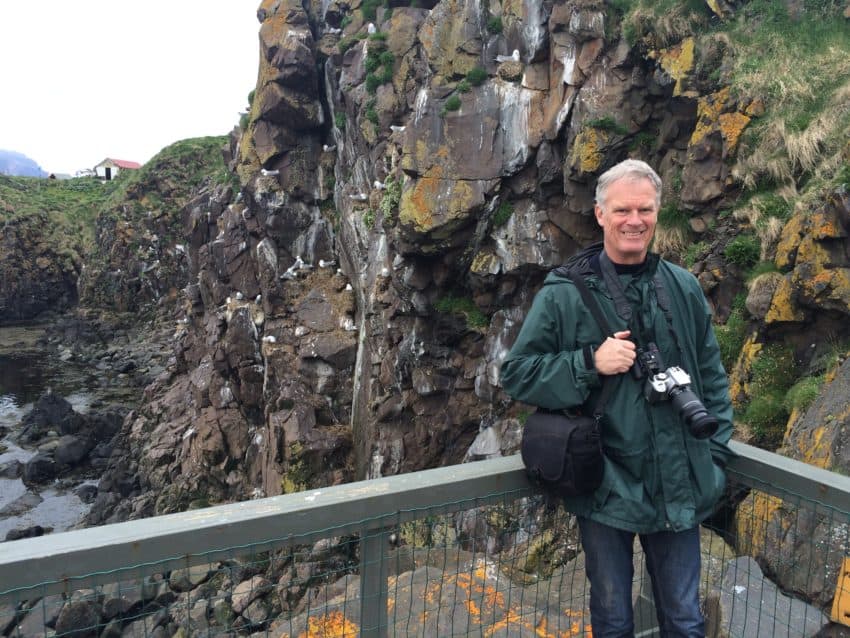
They share their home with kittiwakes, kind of a gull with gray wings, and eiders which look like black and white ducks. I packed a lunch, took some photos, watched the puffins shake rain off their feathers then ate at one of the little picnic tables.
I’ve had worse table settings.
NORTH ICELAND
North Iceland … it just sounds cold, doesn’t it? Foreboding. Isolated. Desolate. All true. But oh, it’s a magnificent mix of stand-alone volcanoes, natural hot springs, bubbling magma pools, lava beds, snowcapped mountain ranges and whale-filled bays. Bring warm clothes, comfortable hiking shoes and a swimsuit. You may not need go anywhere else in Iceland.
My AirBnB owner in the village of Reykjahlio, on the banks of the beautiful Lake Myvatn, works on a search-and-rescue team and knows every hiking trail in the region. He sent me on a 6-mile hike on a trail called Namaskard, named for the modest mountain you must climb to reach the end of the trail.
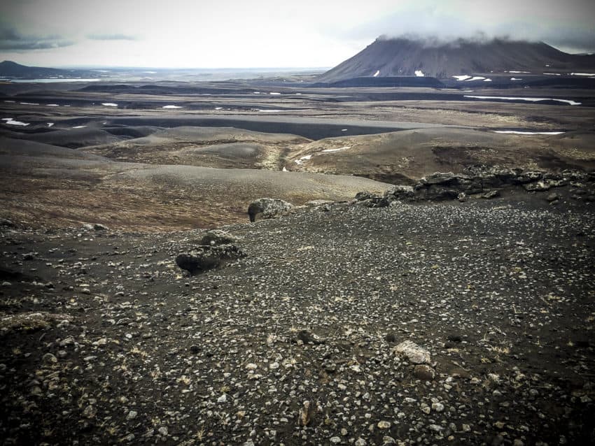
This part of Iceland is one giant cauldron, thanks to a series of volcanic eruptions over the eons. They erupted as recently as the 1720s and then in the 1970s when a series of fissure eruptions known as the Krafla Fires lasted nine years. The end result is land where smoke twirls up from molten magma in ground I toured from safe walkways with badly needed guardrails.
This is true fire and ice. I started the day at Viti, a giant 1,000-foot-wide brown crater with a crystal-clear blue pool partially filled with icebergs. The hiking trail around the rim, and the spectacular vistas of this giant blue pool, provided a good warmup.
My hike started on a lava bed that stretched to the horizon. I was walking through an area where just 300 years ago was one sea of molten lava. The hard, maroon rocks are disorienting. The only path is barely a foot wide.
The hike isn’t very high. It isn’t very hard. But it is absolutely in the middle of nowhere.
And there was no one else.
The only people I saw were a young French couple who hiked to a snowfield where the trail disappears. They returned warning me not to get lost. I did find the trail on the other side and found myself in the center of a geological paradise. I sat down on a tuft of grass next to the lava, munched on a sandwich and trail mix and looked out at the mountain range to my right, the sea to my left and in front of me, standing like a fortress in the sky, was Hverfjall. It’s not even 1,500 feet high but it is majestic in its symmetry. Stretching 3,400 feet across the top and covered in snow, it looks like Kilimanjaro got tired of Global Warming and moved north.
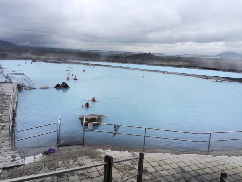
I completed the hike in only 2 ½ hours, good enough to pamper myself with a trip to one of Iceland’s famed thermal pools. Myvatn Nature Bath, five minutes from my AirBnB, opened in 2004. It has two big pools of 95 and 99 degrees and a big Jacuzzi of 108. It’s naturally heated by the bubbling ground and, at $44, is a bargain compared to the larcenous $61 charged down south by the Blue Lagoon, Iceland’s greatest tourist trap.
I met the same French couple from the trail and we sat on ledges talking French cuisine, U.S. politics and travel as we stared out at the snow-capped mountains beyond. Maybe Myvatn Nature Bath is where they should hold the next G7 Summit.
WEST ICELAND
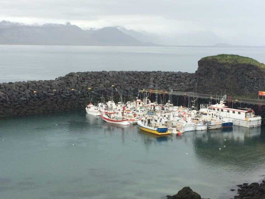
The town of Stykkisholmur is a little port town that sits at the end of a peninsula jutting north into the sea. It’s where you take the ferry to Westfjords, Iceland’s back of beyond frontier in the far northwest. Stykkisholmur is where you take some of Iceland’s best boat tours. It’s where I based a one-day drive around the Snaefellsnes Peninsula, a one-stop shopping tour of geological Iceland.
West Iceland is more inhabited than the East and North. Its fishing villages and port towns look like paintings in an outdoors store. Not only did Jules Verne discover this remarkable corner of Iceland but so did Hollywood. “The Secret Life of Walter Mitty” was filmed here. It’s about a quiet, shy man who gets in touch with his inner adventurer and sets off for Iceland. The film shows him skateboarding past Kirkjufell, the 1,500-foot mountain that seemingly comes out of the sea. Its steep green walls and narrow top make it look like an outdoor cathedral.
Driving around the far western end of the peninsula I got a good 45-minute view of Verne’s Snaefellsjokull before stopping in the charming little town of Arnarstapi. There I stopped in a simple coffee shop where I had a not-so-charming $5 cup of coffee I had to serve myself and ignore the Icelandic cod for $35. But it’s not far from a lookout where you can see the sea in all directions.
Heading back to Stykkisholmur, I thought I’d never come back to Iceland again. It is just cost prohibitive. I felt like I should leave the country wearing a pork barrel. But Iceland should be on any true traveler’s bucket list. The geography is too unique, its history to, well, explosive. It must be seen to be believed. However, I will return in my own way.
I’m ordering “Journey to the Center of the Earth.”
June 8, 2017 @ 4:47 am
I first read about Iceland in a 1970’s thriller book by Desmond Bailey (Running Blind) and for 35 years wished I could go there. 2010 and i got there – thank goodness. Fascinating country. and they just starting to open the Eastern coast . Have to agree with you about the Blue Lagoon – bit of a tourist trap, but with it being on the way to the airport, it makes a convenient stopping off point. Just as easy to go to one of the municipal baths in Reykjavik! I’ll have to save my cash for another trip.
BTW – question – which is the more expensive, Iceland or Norway? just got back from Norway – even the germans thought Norway was expensive!!!
August 29, 2017 @ 4:53 am
Your blog gave me another perspective on Iceland, well it really is a scary thing to live on a volcanic island, when you know the lava is just 50 meters away. The water temperature of the southern islands is really 50 degrees, that’s unbelievable.
August 29, 2017 @ 5:27 am
Yes, it’s that cold. At least if one of the famed rogue waves caught you, you’d freeze to death before you drowned.