

Retired in Rome Journal: Four-day trek starts slow but ends on a very major high
SUNDAY, AUG. 17 — ZELENOM PLESO, Slovakia
I’m sitting in a big A-frame hut in the middle of Slovakia’s High Tatras mountain range and trying to decide what’s the better view: The one to my left through two big picture windows of window boxes filled with pink and white flowers, with a green lake in the background and a craggy mountain climbing to the sky? Snow is on its higher peaks and a series of waterfalls cascade down the rock. Then again, over my right shoulder is a series of picnic benches surrounded by wild lavender and the expanse of the thick green forest stretching into the valley I left far below this morning.
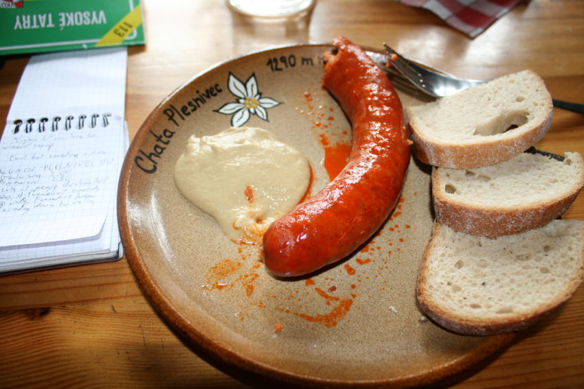
I’ll take the former, merely because I’m so thirsty I could jump in that lake. The only problem with this hut is it only has water with gas, without question the worst invention since the hammer throw. It’s like drinking a 7-Up that has sat in a bowl in the refrigerator for three weeks. I don’t trust the tap water here. My stomach gurgled following my first couple sips. Or maybe it was the PowerBar. Then again, how about my lunchtime bratwurst so long it nearly curled the circumference of my plate at the previous hut?
Nevertheless, Slovakia’s excellent national beer, Zlaty Bazant, quenches my thirst and no ailment can take away from the complete bliss of walking alone up mountains for five straight hours and finding yourself in the middle of unspoiled paradise. When Czech Republic and Slovakia opened themselves up to mass tourism in the ‘90s, Czech Republic was the city and culture destination. Slovakia was the nature destination.
Consequently, Czechs look at Slovaks as their somewhat slower country cousins. Americans flock to Prague, drink its beer, marvel at its women, then leave. Then don’t venture far afield.
I, meanwhile, am in the back of beyond.
The High Tatra mountains is off the beaten path — for North Americans. I haven’t heard a word of English today. However, this is old hat to Eastern Europeans. About 5 million come here for the hiking in the summer and the skiing in the winter. The High Tatras sit on the middle of Slovakia’s spine like a small saddle. in an area covering only about 40 x 15 miles are two dozen black, craggy mountains ranging from 7,000-8,700 feet, all standing out individually like sentries guarding the nearby Polish border. There are 360 miles of trails snaking up from Poprad all the way north to the Polish border 15 miles away. My four-day solo trek is going through what TravelSlovakia tells me is some of the most beautiful terrain in the Tatras. After one day, I can’t be more thrilled.
But after one hour, I couldn’t have been more worried.
TravelSlovakia is a fantastic, professional adventure company that completely prepared me for this escape, from designing the four-day route to providing maps, suggestions, weather reports and a packing list. However, the first trailhead was as difficult to find as a terrorist’s cave. Danka, TravelSlovakia’s representative, told me to tell the bus driver to drive me to the first Tatranska Kotlina stop. First, place names in Czech Republic and Slovakia are impossible to pronounce. They all sound like something you’ve read on an eye chart. I can’t remember one name more than five seconds. Prague is it. The rest, such as Tatranska Kotlina, move in and out of my brain like radio ads. I approached the bus driver with the bus stop’s name on a piece of paper in front of me like I was on a scavenger hut. The bus driver, a burly, burr-haired man with a wispy moustache, looked as if he could no more speak English than I could medieval Bulgarian. I had Danka on the phone and tried holding it up to the driver’s ear, asking Danka to tell him, in Slovak, “Drop him at the FIRST Kotlina stop.” The driver pulled away as if I handed him a ticking bomb.
So I took my seat and hoped for the best. On the way up, I chatted with an Estonian engineer who is motorcycling around Eastern Europe. He told me Slovakia is about 10 years behind Estonia.
“You and I are the only people on this bus who speak English,” he said, indicating English proficiency is the top priority of any culture. He shocked me when he said Slovakia is expensive. I paid 80 cents for a beer in my pension last night.
“Go to Poland,” he said.
He went off in search of a cable car ride to the mountaintops. I went off in search of a trailhead. It was easier to find a hammerhead. A big sign reading “Tatranska Kotlina” greeted me when the driver pulled to the side of the road and pointed at me. This looked like the start of a long four-day trek. What looked like a hiking lodge with it’s roomy lobby and directional arrows was on one side. A souvenir store stood on the other. I walked across the street taking a picture of the sign greeting me on the longest solo trek of my life.
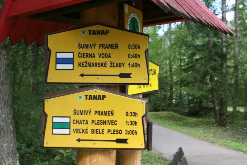
Unfortunately, the sign read “Spider Trail.” It had carved, wooden spider figures hanging from high posts like Halloween decorations. I saw no signs indicating my upcoming destinations: Plesnivec chata. Biele pleso. Zelenom pleso.
I went into the souvenir shop and asked the pretty shopkeeper, “Kde’ Zelenon pleso?” (Where is Lake Zelenon?) Even speaking passable Slovak, I may as well have asked, “Hey, babe, where’s the Wash Park Rec Center.” She didn’t have a clue. She gave me an exaggerated shrug and a frown and I went next door to a tiny information booth. A man with a nametag told me the trial up Spider Land led to a cave filled with spiders. He suggested I take the road toward a hotel down the road. He had no clue, either. At the hotel, the burly female desk clerk with the Soviet-era hairstyle (picture a USSR female shot putter after a three-hour workout and a sauna) said she only spoke Slovak and German. Zelenom pleso was a foreign planet to her, too. So was Plesnivec chata, the first hut on my trek. She consulted a woman in the lobby who sent me off alone on a gravel path that ended in some guy’s backyard.
I returned to the hotel, keeping my cool but wondering which animals will wind up eating my flesh up in the mountains if I struggle this much finding the damn trailhead. Ms. Bolshevik then sent me down the street about 100 meters to what she said would be a map. Walking down a two-lane road with lane markers was not my idea of starting a four-day trek. I resisted the temptation to call Danka. My Italian cell phone charges only 15 cents a minute for foreign calls but I wanted to save the minutes for when I’m stuck in a crevice, temps have dipped into the teens and a bear has discovered the PowerBars in my backpack. I called her anyway and she said she didn’t know what the trailhead looks like.
Huh?
She tried to be helpful and as she left to get some answers, I followed the street until I did see the map. It was a big blue map with an arrow pointing right to the word “Plesnivec.” Another 50 meters brought me to a signpost with directions pointing every which way. I saw an arrow pointing toward a dirt path and “Plesnivec” again. I guess it would help if I could actually read.
My trek was on.
I headed west and immediately ran into thick forest that rolled upward through the trees. Through breaks in the forest, I could see green farmland and valleys below. They all got smaller as I continued to climb. It had rained yesterday so I ran into a lot of mud and it only took one slip to turn my nice do-everything Merrill shoes into nothing but a mud-caked hiking shoe. About 45 minutes from Plesnivec, a rolling river ran below the trees. Nearby a Slovak man showed his 5-year-old son how to read a map. Yes, Slovakia is definitely Eastern Europe’s Colorado.
The weather was perfect for hiking: about 50 degrees and no wind. Still, I sweated buckets in the masked humidity. The incline wasn’t steep, maybe 15-20 percent. But it was relentless. Never did it dip. Never did it flatten. It went up and up and up until it finally reached the modest wooden lodge called Plesnivec chata (“hut” in Slovak). In two hours I had worked off the bacon and eggs, chocolate chip yogurt and slabs of bread with hazelnut spread from breakfast. Meanwhile, as I drank from my water bottle, I looked around and realized what part of the world I was in. Every other hiker on the patio was drinking beer. Tall, dark beers as if they were out with the boys.
I ordered garlic soup and the bratwurst and chugged two glasses of ice cold tapwater. I sat at an inside table with the window perfectly framing the panoramic view of the beautiful valley painted a half dozen shades of green below.
The trekkers here are almost entirely from within driving distance. As I passed people, I’d say “AH-hoi,” (“Hello” in Slovak) and I’d get something unintelligible form a Slavic language I had no hope of recognizing. I saw one young woman with an “Italia” warm-up top. I said, “Ciao.” I got something that sounded Polish for “Drop dead.”
They were lots of families with small children, couples in expensive hiking gear, lesbians in matching haircuts, stocky Germans refusing to wear long sleeves.
I saw only one other solo traveler. A middle-aged Polish woman in calf-length black pants and a turquoise top was my beacon as I followed her up the hill. She was a Polish billy goat, charging up the hill like she was smuggling information over the border.
At one rest stop I said, “How are you doing?”
“This is hard,” she said. “This is my first vacation of the summer and I’m not in condition.”
Later at the crude Biele pleso (“lake” in Slovak) with some picnic tables, I asked if she was going to Zelenom pleso as I was.
“No. Poland.”
We were six miles away. I had no idea. Hiking had indeed made the world seem smaller.
I proceeded toward my final hut and the skyline started to open. At 1:30 p.m., 45 minutes past Biele, I saw my first mountain views. Here the High Tatras look like skyscrapers. Each one is an individual mountain with the sheer rock faces as steep as elevator shafts. They aren’t quite as vertical as Italy’s Dolomites or Yosemite’s El Capitan but they’re close. Snow speckled the peaks poking above wispy clouds.

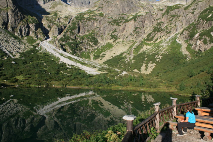
As if on cue, a bitter wind whipped through me. I pulled out my A.S. Roma sweatshirt and hiked through a narrow path of big, slippery rocks. I started wondering where this mythical final hut was until I turned a corner and there it was: a big lodge with some of the prettiest, most majestic views in Europe. I saw a lake so clear the towering mountains reflected off it as if they stretched below the water’s surface deep into the earth’s core.
The hut was packed. Europeans had poured into the dining room slurping up lentil soup and beer. The outdoor picnic tables were filled with hikers who didn’t bother taking off their backpacks before ordering their first brew. Asking for my reservation in English, I felt like an alien from Neptune. Due to the popularity of trekking here, I missed out on a room and I’m on a mattress in the attic, a dark A-frame sleeping area with about 20 mattresses lined up side by side. Trying to strip for a badly needed shower while a couple cuddled in a post-hike nap was challenging.
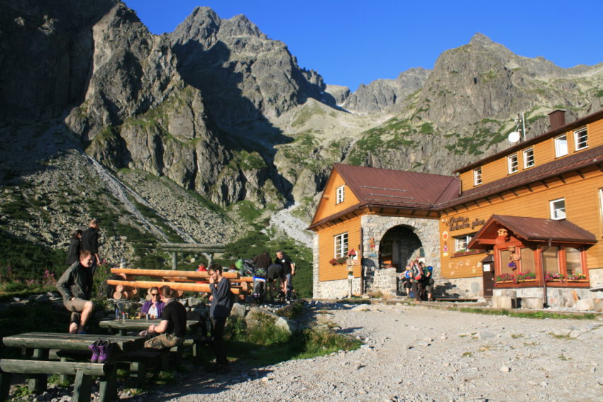
Lots of couples speaking Slovak are here: women wearing stylish stretch pants and the men toting rock climbing helmets and helmet hair. Here the elderly have disappeared. This is a bit too far to walk on a day trip. Then again, I’m elderly and I’m here.
And I’m glad. The Slovak beer is nearly as good as its Czech cousins and the two cats sleeping on seat cushions next to me remind me how life can be too fast paced at times.
In the High Tatras, you can’t go too fast. It’s dangerous, just as in life.